科研动态
科研进展 | 南海U形海疆线的遥感热点研究分析
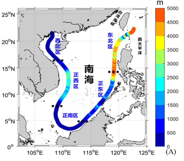

图1 南海地图: A. 南海U形海疆线水深特性及其西北、正西、正南、正东和东北5个区间; B. 部分南海U形海疆线走廊水下部分示意图
Fig. 1 Map of The South China Sea: A. The U-boundary with water depth and its 5 zones of northwest, west, south, east and northeast; B. Sketch map of the U-boundary corridor in the South China Sea
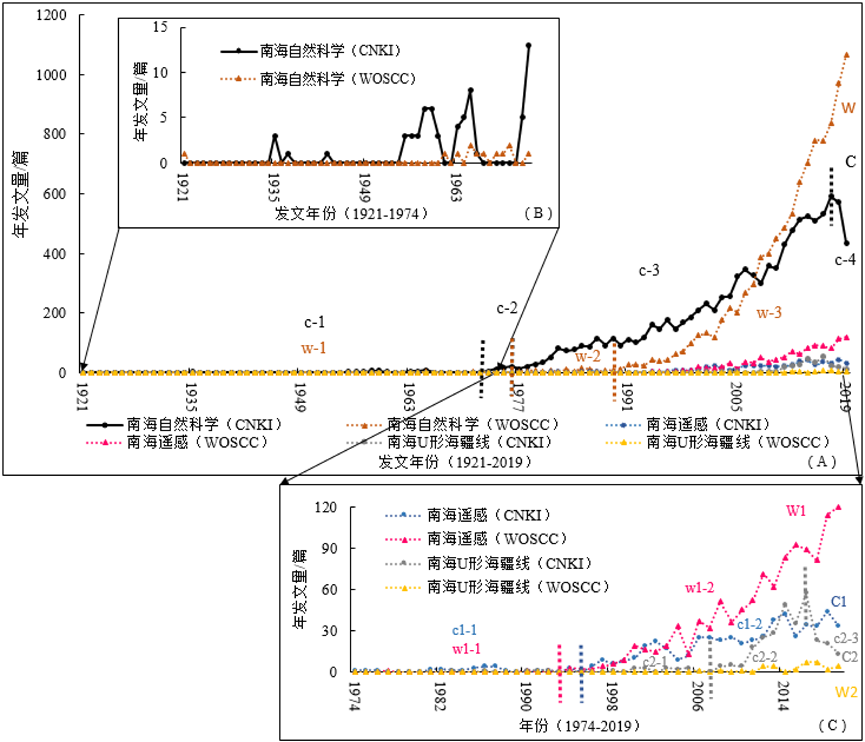
图2 CNKI和WOSCC中南海研究期刊论文年发文量.(A)发文年份为1921-2019年; (B)发文年份为1921-1974年; (C)发文年份为1974-2019年. “c” 代表来自CNKI, “w” 代表来自WOSCC
Fig. 2 Annual quantities of journal articles of the SCS from CNKI and WOSCC. (A)Published from 1921 to 2019. (B) Published from 1921 to 1979. (C) Published from 1975 to 2019. ‘c’ - from CNKI. ‘w’ - from WOSCC
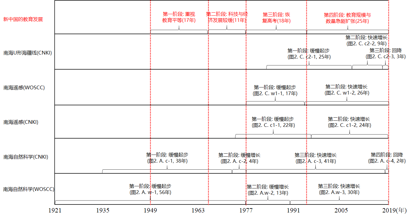
图3 CNKI和WOSCC中南海研究期刊论文年发文量变化的几个不同阶段
Fig. 3 Stages of SCS researches based on annual quantities of journal articles from CNKI and WOSCC
资助:国家自然科学基金项目(41876136, 41430968)、广东省重大人才工程计划创新团队项目(2019BT02H594)、南方海洋科学与工程广东省实验室(广州)人才团队引进重大专项(GML2019ZD0602)等。
论文:唐丹玲,刘旺,隋广军,王颖,王素芬, 2020.文献计量分析南海及其U形海疆线的遥感研究热点[J/OL].热带海洋学报:1-17[2020-12-21]. TANG DANLING, LIU WANG, SUI GUANGJUN, WANG YING, WANG SUFEN, 2020. The bibliometrical analysis of remote sensing research hotspots for the South China Sea and its U-boundary[J/OL]. Journal of Tropical Oceanography:1-17[2020-12-21].
原文PDF请点击:
1)http://kns.cnki.net/kcms/detail/44.1500.P.20201216.1034.002.html
2)http://journal15.magtechjournal.com/Jwk3_rdhyxb/CN/10.11978/YG2020004
3)http://www.lingzis.com/journal%20article.htm(No.165)
参考文献:
刘宇鹏, 唐丹玲, 吴常霞, 等, 2019. 南海U形海疆线的生态环境分区特征[J]. 海洋学报, 41(02):14-30. LIU YUPENG, TANG DANLING, WU CHANGXIA, et al, 2019. Zoning of the U-boundary in the South China Sea and its ecological environment characteristics[J]. Haiyang Xuebao, 41(02):14-30(in Chinese with English abstract).
唐丹玲, 刘宇鹏, 郝晓光, 等, 2018. 国界线和行政区线表示南海U形海疆线的地图[J]. 科学通报, 63(9):856-864. TANG DANLING, LIU YUPENG, HAO XIAOGUANG, et al, 2018. A newly-discovered historical map using both national boundary and administrative line to represent the U-boundary in the South China Sea[J]. Chinese Science Bulletin, 63(9):856-864(in Chinese with English abstract).
骆遥, 李敬敏, 张文志, 等, 2019. 反映南海U形海疆线的《南洋群岛新地图》[J]. 科学通报, 64(23):2390-2394. LUO YAO, LI JINGMIN, ZHANG WENZHI, et al, 2019. A historical Map of East Indies representing the U-boundary in the South China Sea as an international boundary[J], Chinese Science Bulletin, 64(23):2390-2394(in Chinese with English abstract).
The bibliometrical analysis of remote sensing research hotspots for the South China Sea and its U-boundary
Abstract: This paper renovated in taking bibliometrics to analyze journal articles with related themes published in and before 2019, to comprehensively evaluate the situation of ocean remote sensing application in South China Sea (SCS), especially in its U-boundary, we employed CNKI (China National Knowledge Infrastructure) and WOSCC (Web of Science Core Collection) as the representatives of journal article databases in Chinese and in foreign languages respectively. The classifying selection results are as followed: 10150 articles in Chinese and 10130 in foreign languages were published on natural science of SCS, 560 in Chinese and 1296 in foreign languages on remote sensing of SCS, and 309 in Chinese and 33 in foreign language on the U-boundary of SCS. The bibliometrical analysis shows that the country with the most articles in all kinds of languages was China (18253), where the top publishing institutions (such as No.1 South China Sea Institute of Oceanology, Chinese Academy of Sciences) and the journals (such as No.1 Journal of Tropical Oceanography) were primarily from; The annual article qualities on SCS natural science experienced 4 stages (slow start, slow growth, fast growth and fallback), SCS remote sensing experienced 2 stages (slow start and fast growth), while that on the U-boundary experienced 3 stages (slow start, fast growth and fallback); The research hotspots of SCS natural sciences were monsoon, gas hydrate and typhoon, while the research hotspots of SCS remote sensing were Sea Surface Temperature (SST), chlorophyll and typhoon and those of the U-boundary were SCS dispute and geologic feature. Our study finds that it was in 1974 that remote sensing data was first applied on the research of SCS typhoons, and it was in 2019 that remote sensing data was first used on ecological environment research of the U-boundary. It is of great significance to develop comprehensive scientific research on the U-boundary corridor in South China Sea by developing remote sensing technology.
Key words: South China Sea (SCS); The U-boundary of SCS; Ocean Remote Sensing; Bibliometrics; NoteExpress


文字 刘旺
美编 小韦